Resourceful Map Captures Urban Ag Projects Across the Golden Horseshoe
Posted: September 16, 2016
Categories: GoodFoodBites / News from Sustain Members
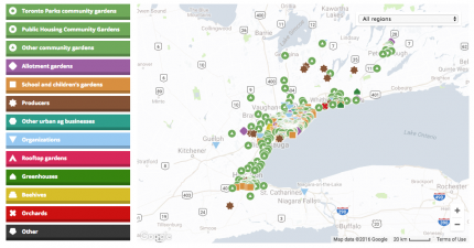
 A resourceful tool for anyone and everyone interested in urban agriculture, Toronto Urban Growers (TUG), a Sustain Ontario Member, have captured urban agriculture projects across the entire Golden Horseshoe on a recently-released interactive map.
The map allows users to search for projects and share their own, ultimately making it easier for people to learn about the plethora of urban agriculture projects in and around their area, all in one aggregated spot. The valuable platform will allow users to connect with potential partners, learn from their projects, and learn about their neighbouring area. The resource will be of great use to many, from gardeners to educators to city councillors to regional employees.
You can view the map categorized by garden type (e.g. community garden, school garden, rooftop garden, greenhouse), and filter by ward or municipal region.
The idea is for the map to continuously grow; TUG hopes that if regions see missing spots in their area, they will help fill out the map and add projects.
Many organizations helped contribute data to the map in an effort to capture all the diverse projects across the Golden Horseshoe Regions; the Golden Horseshoe Food and Farming Alliance, another Sustain Ontario member, contributed $10,000 to TUG to ensure that the map would use and include resources from all regions.
TUG’s website also provides a number of resources and educational tools for urban growers, businesses and organizations in addition to the map. Browse through all the resources and check out the new Urban Ag Map here!
